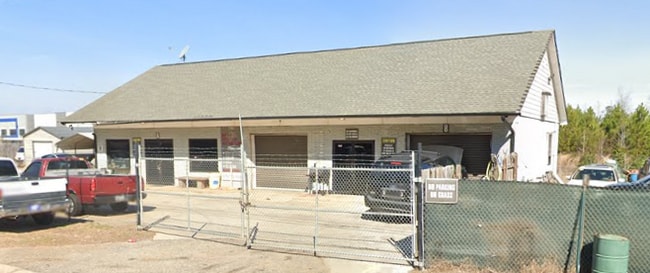
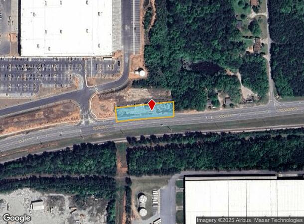
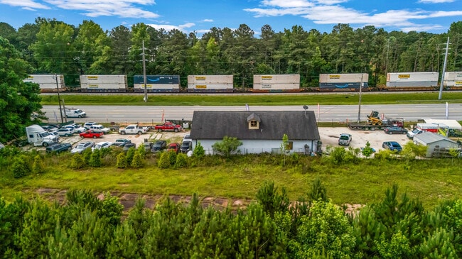
Property Record
7701 Roosevelt Hwy, Fairburn, GA 30213
NEARBY LISTINGS FOR SALE OR LEASE
Property Detail
7701 Roosevelt Hwy
07-3000-0123-018-3
G Neal Ellis Jr & Carrie Lou E
Autorepair
Fulton
X
Georgia
13121C0445F
123
2024
0.91 AC
2025
Airport/North Clayton
010520
Atlanta
2,414 SF
Atlanta-Sandy Springs-Roswell, GA
DEMOGRAPHICS near 7701 Roosevelt Hwy
1 Mile
3 Mile
5 Mile
2024 Total Population
238
14,462
49,222
2029 Population
244
15,054
51,492
Pop Growth 2024-2029
+ 2.52%
+ 4.09%
+ 4.61%
Average Age
43
38
38
2024 Total Households
94
5,238
17,773
HH Growth 2024-2029
+ 2.13%
+ 4.18%
+ 4.59%
Median Household Inc
$58,268
$58,844
$68,988
Avg Household Size
2.50
2.70
2.70
2024 Avg HH Vehicles
2.00
2.00
2.00
Median Home Value
$259,090
$225,254
$246,139
Median Year Built
1989
2001
2001
Nearby Places
Map Layers
Map Styles
 Street
 Aerial
- Restaurants
- Banks
- Shops
- Fitness
- Groceries
PUBLIC TRANSPORTATION
AIRPORT
Hartsfield - Jackson Atlanta International
DRIVE
WALK
Distance
Hartsfield - Jackson Atlanta International
28 min
18.8 mi
Freight Ports
Georgia Ports - Savannah
DRIVE
WALK
Distance
Georgia Ports - Savannah
290 min
256.1 mi
SALE & LEASE HISTORY
LISTING DATE
SALE/LEASE

Jun 28, 2023
For Lease
Jun 20, 2025
For Sale
Jun 14, 2023
For Sale
Jul 23, 2019
For Sale
Jan 20, 2019
For Sale
Feb 27, 2017
For Sale
Nearby Properties
Address
Land Use
TOTAL SIZE
Lot Size
Zoning
Address
Land Use
TOTAL SIZE
Lot Size
Zoning
938,714 SF
103.25 AC
AG1
Address
Land Use
TOTAL SIZE
Lot Size
Zoning
1,000,200 SF
78.26 AC
R1
Address
Land Use
TOTAL SIZE
Lot Size
Zoning
79.51 AC
AG1
Address
Land Use
TOTAL SIZE
Lot Size
Zoning
374,881 SF
91.05 AC
M1
Address
Land Use
TOTAL SIZE
Lot Size
Zoning
1,160,240 SF
71.94 AC
AG1
Address
Land Use
TOTAL SIZE
Lot Size
Zoning
1,094,400 SF
111.68 AC
M1
Address
Land Use
TOTAL SIZE
Lot Size
Zoning
981,874 SF
83.45 AC
AG1
Address
Land Use
TOTAL SIZE
Lot Size
Zoning
907,675 SF
73.12 AC
AG1
Address
Land Use
TOTAL SIZE
Lot Size
Zoning
1,351,440 SF
86.29 AC
M1
Address
Land Use
TOTAL SIZE
Lot Size
Zoning
1,776,355 SF
13.40 AC
PD
Address
Land Use
TOTAL SIZE
Lot Size
Zoning
1,127,500 SF
89.15 AC
M1
Address
Land Use
TOTAL SIZE
Lot Size
Zoning
1,054,500 SF
101.73 AC
M1
Address
Land Use
TOTAL SIZE
Lot Size
Zoning
1,040,000 SF
74.64 AC
AG1
Address
Land Use
TOTAL SIZE
Lot Size
Zoning
1,064,460 SF
23.50 AC
M2
Address
Land Use
TOTAL SIZE
Lot Size
Zoning
873,600 SF
65.24 AC
C2
Address
Land Use
TOTAL SIZE
Lot Size
Zoning
685,260 SF
56.60 AC
M1
Address
Land Use
TOTAL SIZE
Lot Size
Zoning
556,800 SF
32.69 AC
M1
Address
Land Use
TOTAL SIZE
Lot Size
Zoning
510,180 SF
41.23 AC
M1
Address
Land Use
TOTAL SIZE
Lot Size
Zoning
715,114 SF
135.23 AC
M2
Address
Land Use
TOTAL SIZE
Lot Size
Zoning
491,992 SF
48.25 AC
M1
Address
Land Use
TOTAL SIZE
Lot Size
Zoning
48.74 AC
M1
Address
Land Use
TOTAL SIZE
Lot Size
Zoning
23 AC
AG1
Address
Land Use
TOTAL SIZE
Lot Size
Zoning
300,000 SF
66.47 AC
R1
Address
Land Use
TOTAL SIZE
Lot Size
Zoning
350,000 SF
17.54 AC
M1
Address
Land Use
TOTAL SIZE
Lot Size
Zoning
417,540 SF
20.73 AC
M1
Address
Land Use
TOTAL SIZE
Lot Size
Zoning
374,881 SF
34.73 AC
M1
Address
Land Use
TOTAL SIZE
Lot Size
Zoning
242,550 SF
15.82 AC
AG1
Address
Land Use
TOTAL SIZE
Lot Size
Zoning
139,164 SF
48.66 AC
R2
Address
Land Use
TOTAL SIZE
Lot Size
Zoning
201,600 SF
18 AC
M1
Address
Land Use
TOTAL SIZE
Lot Size
Zoning
255,000 SF
20.68 AC
M1
The World's #1 Commercial Real Estate Marketplace
Connect with us
© 2025 CoStar Group
The information above has been obtained from sources believed reliable. While we do not doubt its accuracy we have not verified it and make no guarantee, warranty or representation about it. It is your responsibility to independently confirm its accuracy and completeness. Any projections, opinions, assumptions, or estimates used are for example only and do not represent the current or future performance of the property. The value of this transaction to you depends on tax and other factors which should be evaluated by your tax, financial, and legal advisors. You and your advisors should conduct a careful, independent investigation of the property to determine to your satisfaction the suitability of the property for your needs.